FAQ
Below you will find answers to frequently asked questions related to the Louisiana Watershed Initiative and its regional, watershed-based approach to floodplain management, along with the programs involved in this effort. If you have any other questions, email us at watershed@la.gov.
For questions regarding specific LWI programs, view the FAQ below:
Background
- A watershed is an area of land that drains all of its streams and rainfall to a common outlet, such as a reservoir outflow, the mouth of a bay, or a point along a stream’s channel.
- A floodplain is any land area within a watershed that is susceptible to inundation by floodwaters from any source.
In essence, a floodplain is part of a watershed. Watersheds range in size from small tributary streams to major river basins. Louisiana has a number of watersheds defined by USGS hydrologic unit codes, or HUCs, that are by definition nested within one another. For example, Louisiana is home to 12 HUC4 watersheds, 21 HUC6 watersheds, and 59 HUC8 watersheds, all of which are nested basins or sub-basins within broader watersheds. Since watersheds are interconnected throughout the state, it is clear that actions taken within a watershed can impact flood risk in other areas.
To locate your watershed via an easy, map-based format, visit the USGS website by clicking here.
Floodplain management is a continuous decision-making process that aims to decrease risk and improve the natural function of floodplains. The actions and decisions of a wide variety of people, laws and regulatory agencies affect floodplains. Local and parish governments, zoning laws, building codes, state and federal laws and residents all make their own contributions—either positive or negative. Before the Louisiana Watershed Initiative, the various levels of government in the state were not organized in a way to facilitate comprehensive floodplain management in a coordinated manner.
Louisiana has a mostly flat terrain with an abundance of waterbodies, including 900 named bayous, 110 named rivers and 242 named lakes. The state is also prone to heavy rainfall. FEMA has designated 26,826 square miles of Louisiana as Special Flood Hazard Areas, which translates to 51 percent of the state. What’s more, flood risk appears to be changing, as even areas outside of floodplains are now being inundated.
Gov. Edwards established the Council on Watershed Management to lead the ongoing development and implementation of a statewide, watershed-based floodplain management program through unprecedented interagency coordination and collaboration. The Council is charged with empowering local jurisdictions and communities to implement regional, long-term solutions that follow watershed boundaries rather than local political boundaries. The Council meets regularly and comprises members of the Office of Community Development, Coastal Protection and Restoration Authority, Governor’s Office of Homeland Security and Emergency Preparedness, Department of Transportation and Development and Department of Wildlife and Fisheries.
The Council’s efforts and initiatives are supported by experts who serve on technical advisory groups—or TAGs—with various specialties in areas such as data, policy, engagement, projects and planning, among others. Each TAG is responsible for seeking input from stakeholders throughout the state and providing the best available information to the Council to support effective, coordinated floodplain-management decisions based on objective data and leading science. Each TAG is supported by academics, researchers, private-sector partners and other key stakeholders. Regional steering committees, set up in each watershed region in early 2020, are also assisting and informing the work of TAGs with local expertise.
Watershed Boundaries
The state has 12 major watersheds, which include smaller sub-watersheds that often cross political boundaries. In addition, several of Louisiana’s watersheds are shared with Arkansas, Mississippi and Texas. However, none of Louisiana’s planning or political boundaries have been structured around watershed boundaries, as seen below. This presents significant challenges in floodplain management for watersheds that may include several communities with varying zoning laws, ordinances or funding streams for flood risk reduction.
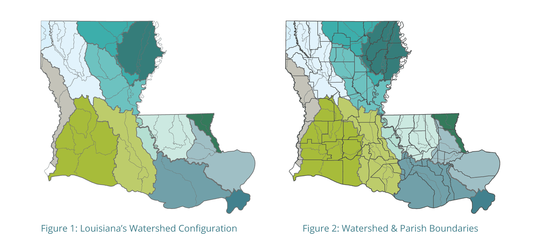
In August 2019, the Council on Watershed Management agreed to use these eight watershed regions as a starting point to coordinate efforts among parishes and distribute project funds. The boundaries are subject to change based on regional input.

Floodplain issues in Louisiana have historically been managed within political jurisdictions, often without the mechanisms to consider the effects on other jurisdictions or the surrounding watershed. Furthermore, state agencies operate with numerous mandates and responsibilities related to floodplain management that are outlined in codes, statutes or federal laws. The various ways in which these responsibilities and relevant programs are managed are often driven by the corresponding funding source, which creates the potential for siloed decision-making and communication.
State and local agencies have made strides in recent years to more effectively coordinate the delivery and management of these programs. For example, the Coastal Protection and Restoration Authority’s Flood Risk and Resilience Program emphasizes the planning for and implementation of nonstructural risk-reduction projects through coordinated policy measures and data management. At the local level, communities like Ouachita Parish and the Acadiana region developed and implemented regional risk-reduction strategies as opposed to narrower jurisdiction-level decisions. The LWI is building upon these and other successful models through effective coordination and collaboration across all levels of government to reduce flood risk throughout Louisiana.
My Community
No. The Louisiana Watershed Initiative is a collaborative effort that relies on input and involvement from several levels of government, especially local jurisdictions. It also leverages state funding received for floodplain management to positively impact the state’s watersheds in an objective, science-driven manner. Local jurisdictions will be fully engaged as policies, standards and project criteria are further defined, with a focus on providing local officials and communities with the clarity and guidance necessary to make objectively informed flood risk-reduction decisions from a watershed perspective in coordination with other local entities that share the watershed.
Possibly. The Louisiana Watershed Initiative coordinates the state’s floodplain management needs and synchronizes related local and statewide outreach and engagement, data management, policy development, technical assistance and master planning. At all levels, this means the state first must obtain accurate and objective scientific data regarding the natural flow of water to inform future decision-making. For example, flooding is tied to the amount of rainfall, but also is closely tied to land use, policy and infrastructure decisions. One aspect of the LWI’s mission is to coordinate these kinds of decisions, since they often affect other areas. In the short term, that means moving quickly to establish a data foundation used to guide decision-making. In addition to obtaining these data, the Council on Watershed Management is working to develop criteria for selecting some immediate watershed-based projects using currently available funding and speeding up the selection and delivery of those projects.
In fall 2018, the LWI hosted a statewide listening tour to gather input from more than 550 technical experts and staff from local jurisdictions throughout the state. The LWI also hosted a number of events specifically focused on engaging local communities in this work, such as meetings in early 2019 with representatives from all 64 parishes, an interstate summit including representatives from neighboring states with shared flood-risk challenges and a best practices summit that convened leaders throughout the U.S. to share their experiences addressing flood risk with local communities.
The LWI conducts frequent and targeted outreach to local communities, as well as to statewide associations, such as the Louisiana Municipal Association, Louisiana Police Jury Association, Association of Levee Boards of Louisiana, Louisiana Floodplain Managers Association and Louisiana Emergency Preparedness Association, among others.
A full schedule of upcoming meetings and events, statewide and at the local or regional level, is located here. You may also request a presentation or meeting in your community here or by emailing us at watershed@la.gov.
One of the core tenants of the Louisiana Watershed Initiative involves building trusting partnerships with Louisiana residents and local jurisdictions through proactive engagement. Residents can keep up with the latest LWI news and future events or news related to flood risk-reduction efforts for your community by signing up for regular email updates here.
Funding and Programs
Louisiana receives federal funding or administers state funds through several programs to manage floodplains in respective jurisdictions. For example:
- The Governor’s Office of Homeland Security and Emergency Preparedness administers FEMA’s Hazard Mitigation Assistance Program;
- The Louisiana Office of Community Development administers HUD’s Community Development Block Grant Program;
- The Department of Transportation and Development manages the National Flood Insurance Program and administers funds through the Statewide Flood Control Program for structural and nonstructural projects;
- The Department of Wildlife and Fisheries administers the Scenic Rivers system; and
- The Coastal Protection and Restoration Authority coordinates the Flood Risk and Resilience Program in Louisiana’s coastal zone.
Historically, these and other programs were driven by their respective funding sources via project awards, funding and/or assistance distributed to local jurisdictions. In addition, local governments often are required to bear a percentage of the cost for each project. The LWI coordinates the delivery of these individual programs to optimize all of the state’s floodplain-management funding going forward, based on data, modeling and project criteria that objectively define the best uses in a particular watershed. Additionally, it empowers local jurisdictions in reducing flood risk within their communities through data standards, policy guidance, best-in-class science and technical assistance.
The Louisiana Watershed Initiative serves as a single coordinating entity to optimize all relevant state and federal funding sources for floodplain management and flood-risk reduction, creating maximum benefit for local jurisdictions and providing greater coordination and leveraging of individual projects and initiatives. For example, one source involves a congressional allocation of $1.2 billion to mitigate flood risk. In February 2020, the U.S. Department of Housing and Urban Development approved the state's Action Plan to use these funds. HUD signed a grant agreement with the state in September 2020 to establish the $1.2 billion line of credit.
The state developed an Action Plan, pending HUD’s approval, that outlines its approach to spending the CDBG-MIT funding on projects, data collection, modeling and policy measures that align with the LWI’s long-term resilience objectives.
Projects will be implemented in three rounds, with the first round providing an initial planned funding allocation of $100 million for local and regional projects that will address immediate flood mitigation needs throughout Louisiana. The grant is also funding the development of watershed computer models that will evaluate projects and programs to reduce flood risk. The models will be used to support decision-making in future funding rounds.
The state and its partners are developing statewide hydrologic and hydraulic (H&H) models to guide LWI efforts to reduce flood risk. These computer models will foster an integrated, reliable and science-based understanding of how water moves throughout the state and how certain activities – such as projects or policy measures – will impact flood risk.
The LWI is leveraging recent modeling efforts such as the Amite River Basin model, lessons learned and best practices to inform how these models are developed and used in the future. The program also involves building out a statewide river and rain gauge network, guided by local input, to assist in collecting data to support watershed modeling, monitoring and flood mitigation efforts.